 The
state of Rajasthan stands as the biggest state of India in terms of
physical cover. The vibrant and historical state is frequented by
travelers throughout the year. The state is located in the North West
part of India. Rajasthan also shares the International boundary with
Pakistan. The state also shares physical boundary with several states of
India like Gujarat, Uttar Pradesh, Madhya Pradesh, Haryana and Punjab.
The state has an area of approximately 342,239 sq km. The state capital
of Rajasthan is Jaipur and the other major cities of Rajasthan are
Jodhpur, Udaipur, Jaisalmer, Bikaner, Kota etc. There are 32 districts
in the state of Rajasthan.
The
state of Rajasthan stands as the biggest state of India in terms of
physical cover. The vibrant and historical state is frequented by
travelers throughout the year. The state is located in the North West
part of India. Rajasthan also shares the International boundary with
Pakistan. The state also shares physical boundary with several states of
India like Gujarat, Uttar Pradesh, Madhya Pradesh, Haryana and Punjab.
The state has an area of approximately 342,239 sq km. The state capital
of Rajasthan is Jaipur and the other major cities of Rajasthan are
Jodhpur, Udaipur, Jaisalmer, Bikaner, Kota etc. There are 32 districts
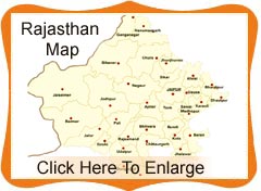
in the state of Rajasthan.A tour of the state will take one to diverse areas of the state wildlife reserves, desert etc. It will be extremely useful for a first time traveler to pick the map of Rajasthan to get a clear insight about the desert cities and forest wildlife cities of Rajasthan. The map of Rajasthan is easily available in the Tourism offices as well as one can find the same online at the internet.


